HomeHenson Gap Radial Ramp


Rev 2/29/2024

Henson Gap Radial Ramp


Matt- -I-launching


BASIC INFO

HG Rating/skills

Hang Gliders only with minimum rating of TTT H2 Novice.

Cliff Launch (CL) and/or Assisted Windy Cliff Launch (AWCL) skills

Wind Direction

Preferred 320°, OK in light winds - 280°-350°

Wind Velocity

Light winds ok, Ideal 5-10mph, Maximum 20mph

Coordinates

35.349331 -85.331661

Elevation MSL

2,380 feet

Elevation AGL

1,420 feet

Glide to TTT LZ

4.4:1


Site Specific Skills - 
Henson Gap - Radial Ramp Launch

  • Hang Gliders only with minimum rating of TTT H2 Novice.
  • Cliff launch (CL) and/or Assisted Windy Cliff launch (AWCL) rating required.
  • First mountain flights permitted under supervision of a TTT BOD approved and USHPA rated instructor or observer at launch and on radio with pilot during flight.


    Flight Requirements

    • You must read and understand our Flight Regulatory Program (FRP) requirements before flying club sites. The FRP is available at the Henson Gap clubhouse and on this web site. Pilots attempting to fly at Henson Gap who violate these requirements are subject to censure.
    • You must be a current Tennessee Tree Topper Member in good standing with a current USHPA membership and rating to fly our sites.
    • You must have an USHPA Hang gliding rating of Novice (H2) or higher.
    • Novice pilots should have mountain flight experience at a different site before first flights at Henson Gap.
    • If you are a Novice pilot, you must be briefed and vetted by a Director prior to your first flight. See the Site Information menu.
    • First mountain flights are permitted only under supervision of a club-authorized observer at launch and radio contact with the pilot throughout the duration of the flight.
    • Tandem flights and student solo first mountain flights are permitted only when supervised by a USHPA certified instructor authorized by the club.
    • Solo student flights require instructor radio contact with the student throughout the duration of the flight.


    Clearance

    • All pilots intending to fly shall have a current Tennessee Tree Toppers and USHPA membership prior to setting up on either launch.This includes kiting on launch. You may join the TTT at Join Now on https://tennesseetreetoppers.org
    • All pilots intending to fly must have a current signed waiver on file.This can be done while signing up online for your membership.There are paper forms in the clubhouse or from a local launch official.
    • Please take time to read our Flight Regulatory Program if you haven’t already.
    • There is TTT Emergency Card with 911 information for each site and pickup information on our website under Members Documents


    Setup

    • Hang Gliders on the radial ramp side should setup back from the launch keeping a path clear to launch for other gliders.Tie downs or safe area for setup gliders is behind the clubhouse or along the tree line between the ramp side and the Burnside launch.


    Henson Gap Radial Ramp Zone Mao

    Hi-res image


    Launching

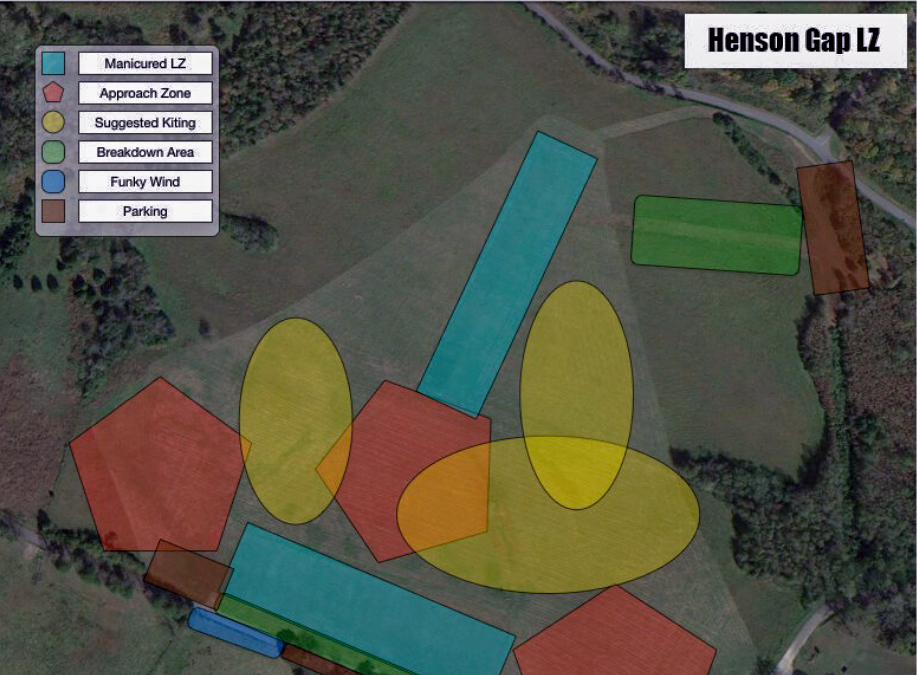
    • Before launching take note of the location of our Henson Gap Landing Zone . There are two sections: Main LZ parallels the road to the south.The lower LZ (good for HGs) parallels Henson Gap Rd to the north.There is a pull-off into the lower LZ from Henson Gap Road.


    Henson Gap 3D visual

    Hi-res 3D image

    • For insurance reasons you cannot launch from the commercial site next door (SVS/Flying Camp) and land in the Tennessee Tree Toppers LZ.
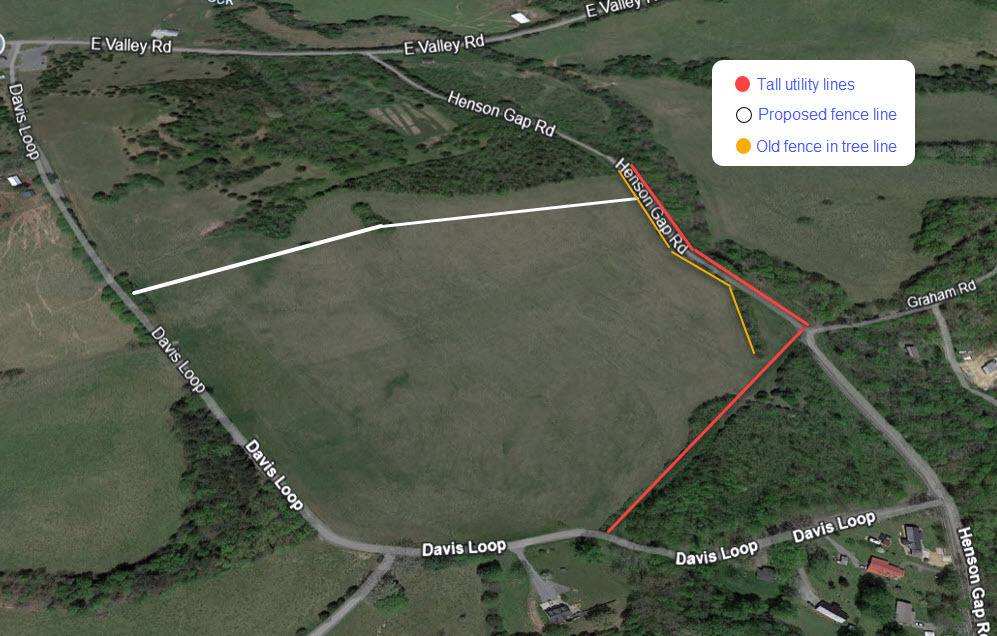
    • 4.4:1 glide to the LZ.Always keep the LZ in sight and be aware of where you are in relation to the LZ. If you are unable to make the main LZ, there are other fields that are landable. Make sure they are safe as far as power lines, fences, etc.
    • Be aware of traffic from the launches to the immediate south and north, both of which are top-landable.There is a commercial PG launch to the south and the Burnside launch to the north.
    • Do not begin the launch too far back. Begin at least at the red line. If a pilot attempts to launch from too far back, they will suddenly enter the vertical airflow at the red line and this may cause the nose to pop up, a lifted wing tip, or a stall resulting in a crash on launch. This is especially a problem when winds are stronger.
    • Pilots should use side wire assistants in winds over 8 mph. A keel assistant is recommended in winds over 12 mph. In such winds it is especially important to launch from forward of the red line and understand how to maintain the proper angle of attack.Be sure to give clear instructions to your wire crew.

    Flying

    • When flying along the ridge, always use the rules of the ridge. To print separately Rules of the Air on our website.


    • As winds increase, a venturi can form in the gap north of the ramp, resulting in less lift and more headwind. Stay well in front of the ridge to avoid being trapped.


    Venturi edited
     
    • Consult the weather forecast for the day and maintain awareness of any predicted severe weather and changing conditions.
    • When soaring, don’t scratch too low or get too far behind launch. Pilots have landed in trees behind launch, please don't repeat their mistakes.
    • Conditions can often be extremely thermic between the hours of noon and 4 pm in the spring and summertime and are often unsafe for Novice and inexperienced mountain pilots.
    • Keep the LZ in site during your flight in case conditions change.There are many other landable fields nearby should you not be able to make our LZ.


    Landing

    • The Henson Gap 40+ acre landing field (LZ) is located north of Davis Loop and south of Henson Gap Road.
    • The large windsock is in the upper LZ closest to Davis Loop and shows the main airflow.There are many streamers throughout the field and they may disagree.Check them while circling the field.When touching down use the streamers closest to your selected landing area as your reference.
    • The upper runway is located at the southern end of the field and runs west to east.It is a gentle slope downhill and then levels off.From here the field slopes down to the north, to a big flat bottom comprising the majority of area.There is a North/South runway and plenty of flat area for either hang gliders or paragliders.
    • The runways are kept mowed most of the time, but the entire field is landable.Be aware that sometimes the grass may be a little higher at times when off the runways.
    • Landing to the SW can be uphill and sinky; you may come down sooner than you think.It is better to undershoot than overshoot.Land towards the open gap in the SW tree line.
    • Upper strip breakdown is along the Davis Loop. Lower strip breakdown – there is a path to the breakdown area which is in the NE corner of the field.Do not breakdown in the landing strip and do not drive out to pick up your glider.
    • Remember that this is a landing field and all landing aircraft have priority.
    • Maintain awareness of any other pilots approaching the LZ and move quickly from the LZ to one of the breakdown areas after landing.
    • Do not pack your glider in the open areas where other pilots might land.
    • Pilots kiting their paragliders should stay well clear of landing areas when hang gliders are flying and should be prepared to lower their wings well before other pilots begin a final approach.
    •  

    Henson Gap Landing Zone

    Hensons-LZ-1


    The upper strip, located at the southern end of the field, slopes upward toward launch in its southern corner. It is fairly level in its western corner bordered by large electric transmission lines (NW) and Davis Loop (SW).From here the field slopes down to the north, along a fall line that divides the upper strip from the lower strip to a big flat bottom comprising the majority of area.
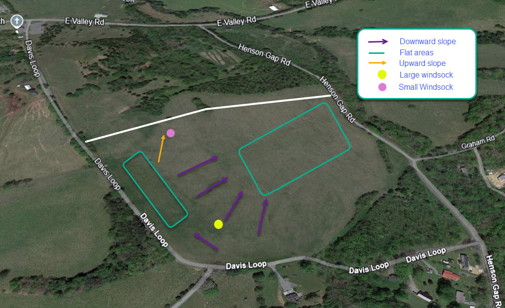
     

    Although the upper strip will be used by many pilots in a strong north cross, the wide flat bottom area may be easier to negotiate in these conditions. Our neighbor Mr. Woerner allows use of his 'bowl field' on the south side of Davis Loop, offering another good option.


    The Henson Gap landing zone (LZ) is located in the field north of Davis Loop and south of Henson Gap Road.  
    View in Google Earth

    Other Important Notes


    • It is a good idea to talk to other pilots about arranging a shuttle to and from the LZ.
    • Henson LZ:
      • Park your vehicle along the tree line across Davis Loop from the main LZ.You may pull in the lower LZ and park just inside the driveway.DO NOT drive your vehicle into the lower LZ past the sign.
    • Pilots should clear their launches and announce their intent before launching.
    • Spectators should be advised to stand by the tree line for viewing whenever pilots are flying.
    • Please take your trash with you and keep your speed down to 15 mph when driving past the homes surrounding the Henson Gap site.
    • Respect the surrounding landowners.

Call Today: (555)555-5555